
What’s underground in Colorado is now being revealed through a searchable oil and gas map online.
The location of oil and gas lines underground is being added to a geographic information systems (GIS) database maintained by the Colorado Oil and Gas Conservation Commission.
That means the public can search for the pipes that connect oil and gas wells.
“This is not supposed to substitute Colorado 811 for locating lines, but it is good knowledge to know where a line is relative to a home or a school, a hospital, a building,” said Chris Eisinger, GIS Supervisor for the Colorado Oil and Gas Conservation Commission.
Colorado 811 is the number you’re supposed to call before you dig, so that utility companies can mark what exists underground.
The database went live last week, but not every pipeline is mapped out yet.
“We have, I think, well over 100,000 segments now on our maps, and we have about 40% of the forms that have been submitted so far still in process,” said Eisinger.
Oil and gas operators have until December to provide the state the plots where pipelines exist, so the map can have all the locations.
It’s a system that’s been pushed for by Erin Martinez since she was injured when her Firestone home exploded in 2017. That blast, caused by an improperly abandoned flowline severed during construction, killed her husband and brother.
“The public has a right to know what is in the ground, in and around, where they choose to live,” Martinez said at a public COGCC hearing on Nov. 21, when the rule allowing this mapping was adopted.
“This is what we’re asking oil and gas companies to provide, is surveyed-line data, which actually shows the true path of a flowline in the ground,” said Eisinger. “The pipe itself, where the pipe is in the ground.”
The online state database allows you to zoom to a level of 1 to 6,000. How close is 1 to 6,000? It depends on what’s on your screen. One inch represents 6,000 inches. One example we saw at the COGCC office got us within three-quarters of a mile.
“The federal government, it only allows you to see this information at 1 to 24,000, whereas the state of Colorado, lets people look at this flowline information down to 1 to 6,000.”
If you want to look any closer, you’ll have to go to the COGCC office or your local county.
“This was done in large part because of security and safety issues,” said Eisinger. “The restrictions are, you cannot reproduce it in any way, meaning taking photos or making printouts of it. That would be the limitation, you can just view it and take notes on it.”
HOW TO USE THE MAP
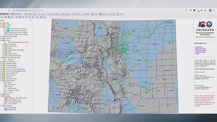
- The map isn’t guaranteed to work on a phone or tablet. Based on our own user experience, it is slow going on a desktop computer, but that’s probably your best bet. When you open the link, you’ll come to a map that looks like this:
2. On the left panel, click the box next to “flowlines.” Black blotches will appear.
3. You can search for an address, like your own, in the top panel. Or, right under the words “GIS Online” use click the magnifying glass with a rectangle to zoom in on one area.
The black lines you’ll see indicate flowlines.
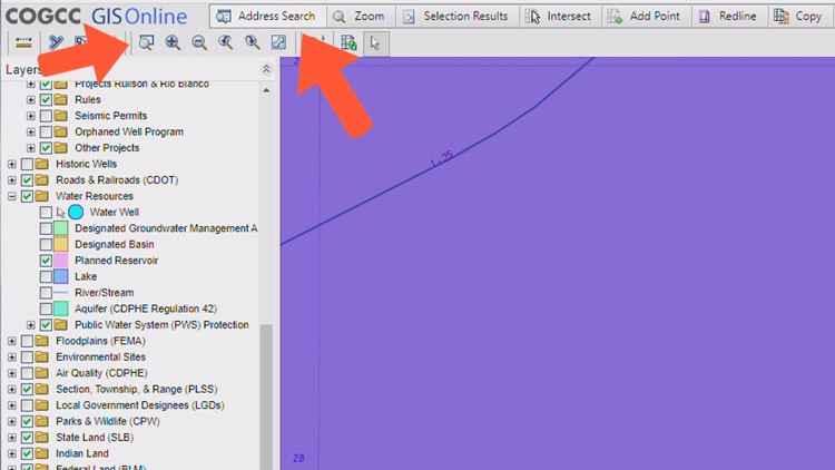
4. After you take either of those actions, a new option should appear on the bottom of the left panel. Under “Aerial Imagery,” click on the box next to 2017 for satellite imagery.
5. Use the hand tool at the top to move the map and use the arrow tool to hover over the black lines and see the flowline information.
Thanks to our friends at 9News for information in this piece.
Recent Posts

The U.S. Department of Labor Announces Proposed Rule To Protect Indoor, Outdoor Workers From Extreme Heat
The U.S. Department of Labor has proposed a new rule aimed at protecting workers from extreme heat hazards. This initiative seeks to safeguard approximately 36 [...]
Supreme Court Overturns Chevron Deference: What It Means for Workplace Safety and Regulation
The landscape of federal regulation is set for a seismic shift following a recent Supreme Court decision. On June 28, in Loper Bright Enterprises, et [...]

Navigating the Compliance Maze: How NARFA Simplifies Employee Benefits for Automotive and Trade Industries
In today's complex regulatory environment, businesses in the automotive, roads, fuel, and related industries face unprecedented challenges in managing employee benefits. Recent studies show that [...]